
Riding & walking routes to explore our churches in Gloucestershire & Bristol
We have created some cycling & walking routes to explore the Jenkins churches described in our booklet ‘Simon Jenkins Favourite Churches Gloucestershire & Bristol. To add to the enjoyment, the walks aim to take in other aspects of Gloucestershire and Bristol heritage and countryside. The routes are in graphic form rather than maps.
With the availability of Google maps, OS apps and other digital route planners, we leave the detailed planning to you. The routes can be seen clearly on OS 1:50000 maps.


Cheltenham Churches
Great Badminton Cycle Routes
9th September 2023 - Here are three routes for September’s Ride and Stride, with the roads, churches and miles between each stopping point.
Ride and Stride route in 2025
This route includes free car parking instructions and a café at the halfway point.

Little Washbourne route
From Cheltenham to Winchcombe over Cleeve Hill, then via Greet and Gretton up to the B4077, where you can stop at Little Washbourne.
Returning to Cheltenham via Alstone, Gotherington, Bishop’s Cleeve and Cheltenham Racecourse.
It is a 22-mile round trip.
Other churches on or close to the route are:
- St Mary’s, Prestbury
- St Peter’s Winchcombe
- Christ Church, Gretton
- St Mary’s, Little Washbourne
- St Margaret’s, Alstone
- Gotherington Old Chapel, Gotherington
- St Martin’s, Woolstone
- St Michael’s, Bishop’s Cleeve
- All Saints, Cheltenham.
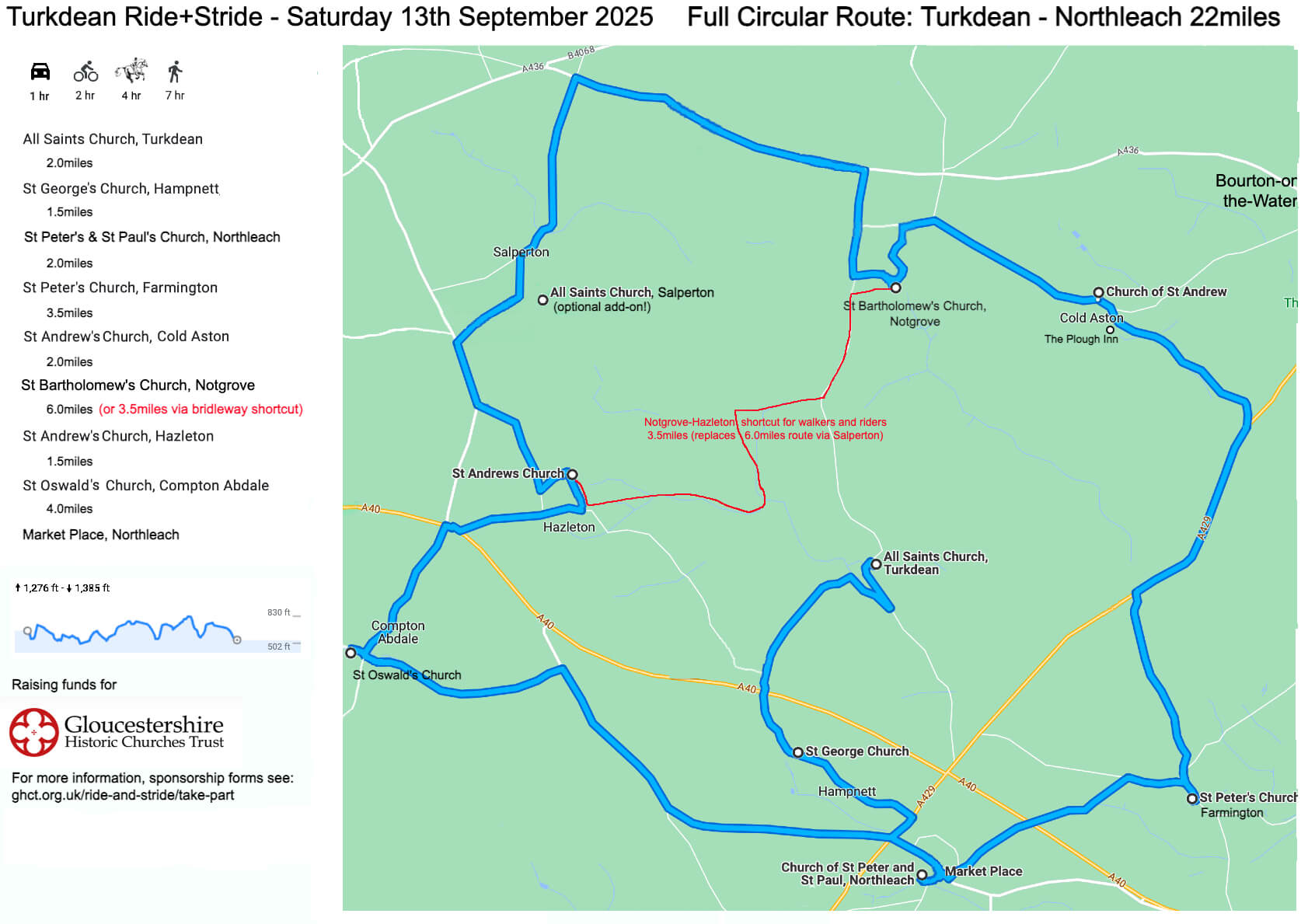
Turkdean route
Turkdean Ride+Stride
Saturday 13th September 2025
Full Circular Route: Turkdean - Northleach 22miles
Coln River Group Churches Run
Country walk visiting two historic churches starting in Hawkesbury
OS grid reference: 768869
Postcode GL9 1BN.
From St Mary’s Church, Hawkesbury to Holy Trinity Church, Wickwar
Approx. 3.5 miles, 1.5 hours. Easy-moderate Lanes, fields and woodland tracks some of which may be muddy. You may encounter cattle, horses, and sheep. Dogs should be kept under control around livestock.
Leaving St Mary’s churchyard turn left and follow the lane to the bottom of the hill. Turn left and then right into Newhouse Farm Lane. Follow the lane until you pass houses and continue straight on along a grassy track (passing some farm trailers). Take first left and through a gate into a field. Turn right. Follow the hedge line until the far right-hand corner of the field and look for a small gap in the hedge leading to a gate into another field.
Go through the gate and go straight on leading to a metal ring feeder in the middle of the field. At the ring feeder carry straight on down to a small bridge in a dip. Cross the bridge and then bear left to an open gateway by a telegraph pole. Keep on this line and then turn right onto a track. Follow this track until you come to Lower Woods Lodge. Cross the car park and after the buildings turn right up two steps and through a kissing gate into a field. Turn left and walk along the hedge boundary to a 5-bar gate on the other side. The gate may have a chain securing it, but the padlock should be unlocked.
Go through the gate straight on to The Walk – a wide grassy track that narrows and can be muddy. Ignore all side turnings until you reach a crossroads (where you can see a small gate straight ahead). Turn right at the crossroads to reach a small wooden gate out onto a track. Turn left on the track for a few yards then turn right by a trough. Keeping the hedge boundary on your left, walk until you come to a gate on your left. Go through the gate, over a small bridge and straight on keeping the hedge boundary on your right. Go through a gate into the next field. Wickwar should be visible now.
Keep straight on and over another bridge, up some steps to a metal gate, through the gate and up a short hill (about 200 paces) then through two metal gates close together towards the houses.
Once near to the houses take the right-hand gate into a field and follow the left hedge line for a few yards turning left through a well-used gap to the back of house number 16.
Turn right onto a small green, take 2nd left passing through 6 small wooden bollards into Avon Crescent. Continue past a pinch point in the road and turn right onto a short path to cut through to Turnpike Gate. Follow the road to the right and then down to Station Road in Wickwar.
Cross over Station Road and turn left up the hill for a few yards. Turn right by the church board, and go up the path to the church. You will walk across The Stank (a dam).
Enjoy your visit.
Country walk visiting two historic churches starting in Wickwar
Grid reference: ST 72348 88921
Postcode: GL12 8NB
Leaving the church, go down across The Stank and turn left onto Station Road. After 50 yards cross the road into Turnpike Gate. Turn left opposite number 44 and left again to pass number 21 then cut through on the right into Avon Crescent. Turn left and at the end of the road pass through some wooden bollards onto a small green and turn diagonally right to a track behind the houses. Opposite number 16 (green dustbin against the garden fence has this number on its front) turn left into a field and then immediately right along the hedge line. Go through the metal kissing gate and turn left into the field.
Keeping the hedge line on your left, walk down the field and go through two metal gates close together. Keep straight on and through another metal gate.
Cross the track and go down some steps. Go over the bridge into a field. Go straight on up the slope; as you go up you will see an oak tree in the hedge line - go through a wooden gate next to it. Cross the next field, keeping close to the hedge on your left, to a gate at the far end. Ignore the gate on the left.
Through the gate and over the small bridge turn immediately right and follow the hedge line until you meet a track. Turn left onto the track and after a few yards turn right through a small wooden gate into the woods.
At the first junction of paths turn left onto The Walk – a long grassy track that can be muddy in places. Ignore all side turnings and at the end go through a 5 bar gate into a field. This gate may be secured by a chain with an open padlock. Cross the field towards the Lodge and exit through a kissing gate in the right-hand corner onto a track. Turn left and cross the car park taking the right-hand stony track.
Follow this track eventually reaching a cattle grid. Continue towards the house and go diagonally left (on an obvious grass track) towards an open gateway by a telegraph pole. Once through the gateway bear right towards an electric pole and before reaching the pole find a stile and bridge in the hedge line into another field.
In this field walk straight on, up a hill, to a ring feeder. Continue straight, keeping a small water trough to your right, to find a metal gate. Go through the gate – there are overgrown brambles on the other side. Turn left and walk along the hedge line exiting the field in the far left-hand corner onto Hawkesbury Common. Bear right towards the houses and join the track/road past the houses. Stay on this road until a junction. Turn left and then right (signposted Hawkesbury) to go up Church Hill and to St Mary’s.
You have reached your destination!
Country walk visiting three historic churches
Starting in Hawkesbury
OS grid reference: 768869
Postcode GL9 1BN.
From St Mary’s Church, Hawkesbury to St James’ Church Horton and on to, Wickwar if wanted.
Approx 1.5 miles to Horton
Easy. Suitable for mobility scooters.
Leaving St Mary’s churchyard turn left and follow the lane down the hill. At the first junction – signposted to Horton – turn left. Continue on this lane for about one mile and you will reach Horton Church.
Return to St Mary’s by the same route or press on to Wickwar which is about 4 miles, 2 hours, easy to moderate.
The onward route to Wickwar is not suitable for mobility scooters.
Starting in Horton
OS grid reference ST7660185045
Postcode BS37 6QR.
From St James’ Church, Horton to Holy Trinity Church, Wickwar
Approx. 5 miles, 2.5 hours. Easy-moderate.
Lanes, fields and woodland tracks. Some may be muddy.
You may encounter cattle, horses, and sheep. Dogs should be kept under control around livestock.
Leaving St James’ church turn left and onto the lane as far as the first bend. Here, join a bridleway on your right. Follow the well-used trail passing through another gate.
At the next gate ignore the well-trodden route across a field and instead turn right. Walk along the hedge line bearing left towards the end and a metal gate. Go through into a field and bear slightly left to another metal gate, through and straight on to a kissing gate, out onto a lane. Turn right to go along the lane.
Continue until you get to Bix House (pass Vinney Lane) and turn left onto the lane, eventually passing Holly Cottage and Stephens Cottage. Continue until a junction of multiple routes and take the left-hand lane. Follow this lane which eventually becomes a track.
Join the track and continue straight ahead. Pass a footpath sign and continue bearing left until you reach a clearing. Turn right here and follow this track into woodland. The track narrows and may be muddy in places.
Follow this track, ignoring one turn to the left and one to the right. At the next option bear right and continue ahead as the trail winds through woodland. At the next clearing, where there is also a trail marker post, bear left on the footpath.
Continue left at a large fallen tree and follow the path past more fallen trees to reach a metal kissing gate. Go through the gate and turn right going into a field. Cross the field to a gate in the righthand corner. Go through the gate and carry on keeping the hedge line on your right. Drop down to a gateway and bear left. Follow the left-hand track through a tree arch and then continue through a group of trees. You may see a stile on your left. Ignore it and look for a kissing gate a little further on, on the left. Go through and over a small bridge. Turn right and up a small hill to another kissing gate. Go through turning left onto a lane and almost immediately right through another kissing gate. Go straight ahead keeping close to the hedge on your right. Go through the gate, cross the bridge and up a few steps into a field. Bear right and follow the hedge line to the next kissing gate. Go through and drop down into a gully, turn right then quickly left up a short slope. Admire the Roman bridge.
Turn left through a metal gate then immediately right. Follow the track until a small metal gate on your left. Go through and on through two more in quick succession, bearing right. After the second gate turn left and after a few yards turn right up a short hill to a kissing gate on your left.
Go through and follow the trail towards some houses and another kissing gate. Go through and turn right. Follow this path along a mesh fence and then between the houses. Cross a street and continue between the houses until you exit by a dog poo bin. Bear right onto Back Lane. Follow this to the end and turn left onto North Street. At the next junction turn right, pass the pub and traffic lights and continue to the Zebra crossing. Cross the road, continue downhill for a short while then turn left at the church sign. Walk across The Stank (dam) and go up the path to the church.
Return route – from Wickwar to Horton – which is slightly different, or follow the first route in reverse
Leaving the church, cross over The Stank and turn right onto Station Road. Cross at the Zebra crossing and continue up the hill. Pass the pub and turn left into North Street and then right into Back Lane. At the end on the lane continue on a foot path between the houses. At the school fence turn right and follow the path through a kissing gate on your left into a field. Follow the well-worn track bearing right to a kissing gate. Go through the gate and turn right. At the bottom of the slope turn left and pass through three small metal gates in quick succession. Turn right after the third onto a wide grassy track.
At the alligator log turn left. Go through a metal gate. Admire the Roman Bridge but do not cross it, instead turn right and follow the track down and up to a metal kissing gate on your left. Go through and follow the footpath keeping the hedge on your left. Go through a gate in the left-hand corner, cross the bridge and go across the field keeping close to the hedge on your left. Exit via a kissing gate onto a lane. Turn left and almost immediately right onto a marked footpath. Once through the gate turn left. Go up the slope and then down following the trail to the right. Cross another bridge and turn right. Follow the trail keeping close to the righthand hedge. Join a wider track through a gateway and up a hill, keeping left until another kissing gate. Go through and bear left to walk along the left-hand hedge boundary. At the end of the field turn left through a kissing gate into Lower Woods (nature reserve).
Go straight ahead following the trail which winds around several fallen trees. Shortly after some piles of brash on both sides you will come to a large fallen tree on your right, close to the path. Bear right here. Shortly after you will come to a forked route, take the righthand trail and keep bearing right through a recently cleared area. In the cleared area, and shortly after where a track joins from the right, the trail divides around a tree with a blue bridleway marker on the trunk. At this point turn hard left onto a narrow path. Keep straight ahead on this path, going up and down, across and small stream and ignore all temptations to follow side trails, until a junction of multiple routes at the end of the woods. Take the path straight ahead by a collapsed gate into a field. Horton Church will be visible straight ahead in the distance.
Cross the field bearing right to wooden gate. Go through into the next field bear left to follow the left-hand hedge line down to a stile and bridge. Go over and cross the next field bearing slightly left away from the buildings to a gap in a hedge. Go through and on to a stile. Go over and turn right towards a building and a gap in the fence, on through a gate and onto a lane. Turn left on the lane.
At the next junction take the right-hand lane and follow this to the end by Bix House. Turn right here onto King Lane.
Continue on the lane passing Knightsbrook, Vinney Lane and Horton Farm. Just after the farm and bungalow (Southwold) take the footpath on the left.
Go over a small bridge and through a kissing gate into a small field. Turn left and, hugging the hedge by the bungalow, proceed towards a metal gate. Go through, bear right and, keeping the mid-field telegraph pole on your left, proceed to another metal gate. Go through this gate and turn left.
Hug the left-hand hedge line to the top of the field and find a wooden gate tucked out of sight in the left-hand corner.
Go through this gate and straight across to another gate. Before going through the gate, turn around and admire the view. You should be able to see the Tyndale Monument on the far right in the distance, and if it is sunny, the sparkle of the River Severn. Now go through the gate onto a well-used trail going straight ahead towards the church. Ignore a side trail on your right that leads to a house.
Just one more gate and bear slightly left on the lane to reach your destination.
‘Ride and Stride’ – a walking circuit around Cheltenham
Start: St Gregory’s RC Church
Make your way to the Honeybourne footpath, either via Jessop Avenue and across the Waitrose car park or (more pleasantly) along the strip of parkland just to the south running alongside the River Chelt. Turn North onto the footpath/cycleway via two underpasses. Once across the white bridge over the road take the turning to the right which will take you to the Winston Churchill Memorial Gardens and walk through these to:
1. St Mary’s Mission and Cemetery
Not a church as such but formerly a mortuary chapel and now a Martial Arts Centre. However, the information boards give fascinating insights into the earlier life of this historic and still attractive site. Proceed a few yards up the High Streets (east) and turn left up King Street to:
2. Francis Close Hall (University of Gloucester) and visit the Chapel
Beautiful campus was founded in 1849 by the Revd Francis Close for the training of teachers in an evangelical Anglican tradition. The chapel is at the centre of the compact campus. About 100 yds further along St Paul’s Road (east) you come to:
3. St Paul’s Church
An imposing early 19th-century building which gives its name to the district. Return to the High Street and continue east until turning off on the south side into what is now called the Minster Quarter.
4. St Mary’s Minster
The oldest parish church and churchyard in Cheltenham. In the heart of the oldest section of the town. Styled a ‘Minster’ in 2019. Return to the High Street and in a few yards turn north up North Place and make your way to Portland Place and:
5. Trinity Church (and Cheltenham Quaker MeeMng House)
Another major Victorian building which looms over the car park opposite. The small modern Quaker Meeting House is tucked behind it in Warwick Place. Make your way to Pittville Circus and from there to All Saints Road. A few yards along the road and to the left is:
6. All Saints Church
One of the most remarkable Victorian buildings in Cheltenham with a rich and evocative interior. Carry on down All Saints Road and continue into Hewlet Road. A few yards down turn left into Carlton Road and shortly later turn right into Priory Terrace and:
7. Highbury CongregaMonal Church
A large early twentieth century brick building siting at the centre of a quiet residential area which replaced an earlier chapel known especially for its work among poor children in the area. Carry on down Priory Street down to London Road. Cross the road and go a few yards down College Road where you will find on the right:
8. St Luke’s Church
A confident and attractive Victorian Gothic building in a square of similarly attractive residential dwellings. Carry on going down College Road and then make your way onto Bath Road, continuing in a southerly direction until you come to Exmouth Street. Turn left here and make your way to the nearby:
9. Emmanuel Church (and Leckhampton Baptist Church)
Emmanuel is a delightful Art Deco building from the 1930s in an area developed around the same time. The small brick Baptist Church is in nearby Pilley Road. Turn left onto Leckhampton Road and turn right into Hall Road and then continue right into Church Road. You will soon find yourself in a more rural landscape where, not too far along and on your left you come to:
10. St Peter’s Church, Leckhampton
An ancient church in an idyllic location with its churchyard and surrounding fields – but only a stone’s throw from Cheltenham itself! Make your way back to Leckhampton Road and turn back towards the town. When you reach the Bath Road again, turn left almost immediately into Grafton Road where you will find:
11. St Philip’s and St James’s Church, Leckhampton (and St Stephen’s Church)
Pip and Jim’s is much loved and another example of what might be called the heroic age of Cheltenham church building as is St Stephen’s, which is a relatively short distance away in St Stephen’s Road off Park Road. From Pip and Jim’s continue towards the town along Painswick Road and make your way via Lypiat Terrace to Malvern Road were on your right you will come to:
12. Christ Church, Cheltenham
Gigantic yet elegant and surely one of the most breathtaking buildings in Cheltenham. Turn left immediately beyond the church into Overton Road, then left into Parabola Road and left into Bayshill Road. Go straight across the traffic lights into St George’s Road, left into St James’s Square and right at the roundabout, and St Gregory’s is there on your right. Give yourself a pat on the back!!
A Note on the Route
The intention has been to create a route for walking that makes a circular journey around Cheltenham and which takes the ‘strider’ through some attractive and historical parts of the town and, where possible, away from main roads. The stopping points are at fairly regular intervals, around five to fifteen minutes walking distance of each other. The two exceptions are (4) St Mary’s Minster, which brings the strider into the centre of town and (10) St Peter’s Church which takes her/him further out. Either of these could be omitted. From (3) to (5) omiVng (4) is a direct walk east and from (9) to (11) omiVng (10) is a very short walk north, crossing the Bath Road. However, both (4) and (10) are highlights among the churches of the area and (10), in particular, gives the strider a welcome breath of fresh country air and the urban nature of the previous stops.
Another way of shortening the route would be to start at (4). Indeed (1) and (2), though fascinating, lie slightly outside the main purpose of the walk. However, both are highly interesting and take the ‘strider’ to the west side of the town, an area that is often overlooked.
The walk is designed to take the whole day in its entirety. As to lunch, given a relatively early start, the strider should find him/herself in the Bath Road by lunchtime, an area which is awash with deligh[ul cafes and pubs. Alternatively, the strider might prefer to delay gratification and consume a packed lunch on arrival at St Peter’s Leckhampton, the furthest point away from the centre of Cheltenham and a beautiful spot in which to take stock, to contemplate the pleasures already enjoyed on the route and to anticipate those to come. I would welcome any comments on the route from those who attempt it, especially with an aim to streamline and improve it. Please send these to: mikebandrews@yahoo.co.uk
Local Organiser Information
All you need to know if you are a local organiser
Ride+Stride National Site
The national site for Ride+Stride events
National Churches Trust
Find out about the national organisers of Ride+Stride